


The key to finding most fish in the waters of Destin is to either find the schools of bait fish or to find the structure where bait fish and their predators tend to congregate. During the summer months, schools of bait fish tend to hold in the troughs and outer bar near the beach and along the bar just outside of the jetties at the Destin East Pass. Offshore, you need to find the structure (either bottom structures such as artificial or natural reefs or near the surface in the form of tide lines or floating debris. To find this structure, you need to know a little about the geology of the ocean floor south of Destin. The sea floor in this part of the Gulf of Mexico consists of the same white sand you see on the beaches. Along the shore, a combination of wave action and tides has formed some structure in the form of three sand bars that parallel the beach. Between these bars are deeper water referred to as troughs. From the water's edge you will find a shallow trough, then a sandbar, then a larger trough 100-200 feet wide, another bar, another trough and finally - an outer "bar" which is really no more than where the bottom begins its final slope down. The trough closest to shore is only there at high tide.In it, you might find a whiting or even pompano at high tide, plus some schools of small bait fish. It is shallow, only a few feet at the most, and may be non-existent at low tide. The second trough is where you will start to find more fish- (depending on the time of the year): Pompano, Redfish, Jacks, Bluefish, Ladyfish, Spanish Mackerel, and maybe a Cobia in the spring. This second trough is 100 to 250 feet wide and from 15 to 25 feet deep. It ends at the second sandbar about 250 feet from shore. The water shallows to 10-15 feet on top of this sand bar, then gradually starts to deepen again until the third or outer bar which is where the big boys - sharks, cobia, king mackerel, porpoises (flipper) patrol the seaward side of this outer bar. Schools of other fish such as pompano, jacks, and bait fish are often seen here too in the summer. The sea bottom out to about 2 miles from shore is nothing but white sand, with no natural bottom structure. It has been referred to as a "desert" of sand due to its lack of any fish attracting structure. To attract fish to this area, numerous man-made structures have been sunk. These include tug boats, barges, concrete/steel pyramids, concrete rubble from construction projects, and even US Army M-60 main battle tanks. Fish gathering around these artificial reefs include: Red Snapper, Gag Grouper, Triggerfish, Porgies, resident Warsaw Groupers inhabit some of the artificial reefs in this area. For example, the tug boat "Miss Louise", sunk in 50 feet of water only 0.7 miles off the old Crystal Beach Pier at the end of Pompano street in Destin. The Urchin and Sand Flea reef complexes lie only about a mile south of Henderson Beach State Park in 50-60 feet of water. They consists of over one hundred 12' high concrete/steel pyramids. The popular Bridge Rubble from the old Destin bridge lies in several spots about 1 1/2 miles off of Holiday Isle. And, about 2 miles south of the Okaloosa Pier lies several man made reefs, the Pole Spot, Barrell Barge, and several US Army M-60 tanks. All of these man-made structures have created fish habitat for the bottom congregating fish in this otherwise barren area. Beginning about 2 miles south of the shore line in around 60 feet of water, small outcroppings of limestone rocks and ledges begin to appear, breaking up the otherwise bare sandy bottom.They are from a few inches to several feet high. Some coral grows on these rocks but do not reach the size of that found further south in the Florida keys due to the cool temperatures in the winter months here. These areas of natural rock reefs consists of only a few rocks or can run into several square miles of rock outcroppings. To name a few: Airplane Rock, White Hill reef, Anniversary Reef, the South East Rocks, the Eighteens, the TImber Holes, Grayton Rock, and many others. Fish found around these reefs include Red Snapper, Groupers, Triggerfish, Porgies and bait fish. The Vermillion snapper ( aka Mingos, Beeliners) start to show up in waters over 100 - 130' deep and larger amberjacks can be found around vertical structures such as the tugboat Belize. The floor of the Gulf of Mexico continues its gradual descent as we head south until we reach about 16 miles due south of Navarre Beach, or about 23 miles south west of the Destin East Pass. The white sand begins to turn into a darker sand, silt, mud or rocky bottom. We start to get more rocky outcroppings but there is still a lot of empty sand. The depth has reached to about 130' deep and it has been a gentle decline from the shore. At this point, the waters have reached to about 130' in depth. It is at this point where we come to the continental shelf of this part of the Gulf of Mexico and is referred locally to as "The Edge". From the point 16 miles south of Navarre, the bottom begins a steep descent into the depths, going from 130' at 16 miles to over 400' deep at 24 miles. The continental shelf in this area is shaped like a broad arrowhead, with the point just south of Navarre. From this point, it curves back to the southeast and south west, ie, the Southeast Edge and Southwest Edge. The edge and points south is the prime fishing area for Destin. This is where you will find the big grouper, amberjack, dolphins, tuna, billfish, and wahoo. |

A school of Ruby "Red Lips" swim
around the sunken tugboat "Miss Louise"
around the sunken tugboat "Miss Louise"

First sand bar
Trough
12' concrete/steel pyramids go down into the waters about 1 1/2
miles south of Henderson Beach state park to form part of the
Sand Flea reef complex.
(Okaloosa County photo)
miles south of Henderson Beach state park to form part of the
Sand Flea reef complex.
(Okaloosa County photo)


To attract fish to the barren sandy areas from the shore out to the edge, artificial reefs have been placed on the sea floor. Years ago, fishermen would haul out old car bodies, buses, washing machines, etc to provide this structure for fish. Now, the placement of anything on the ocean floor is closely monitored and regulated. As you can imagine, it is no longer simple to do. The main government agency that controls what can be placed on the floor of the Gulf of Mexico for United States territorial waters is the US Army Corps of Engineers. The Jacksonville office controls the waters off the panhandle of Florida. (US Army Corps of Engineers - Jacksonville web site ) Practically speaking, the Pensacola office, located at: 41 North Jefferson St. Suite 111 Pensacola, FL 32502 has overall field control of permitting the reefs in our area. (Pensacola Corps of Engineers Contact Numbers ) The Pensacola Corps of Engineers has in turn placed the counties with direct access to the Gulf in charge of the actual day-to-day administration and permitting of artificial reefs in our area. Destin - Okaloosa County (Okaloosa County Resources Division web page ) does the actual permitting for artificial reefs in the Destin area. Pensacola - Escambia County (Escambia County Marine Resources web page ) does the actual permitting for artificial reefs in the Pensacola area. Panama City - Bay County ( Bay County Artificial Reef Permitting ) does the actual permitting for artificial reefs in the Panama City area. Each county is provided yearly permits from the Corps of Engineers for designated areas off their coast in which they can allow artificial reefs to be placed. These areas are called LAARS ( Large Area Artificial Reef Sites). |

Okaloosa County photo

| Who owns these reefs and fishing spots? You do. Someone can spend thousands of dollars to make and transport an artificial reef to "their spot", but once it sinks to the floor of the Gulf of Mexico, it becomes public property. For this reason, gps numbers to privately deployed artificial reefs are guarded tightly and not freely disclosed. As it should be, as these private reefs are the livelihood of the commercial charter fleet and private (aka: monkey boats) who have invested time and money to deploy them. It is considered unethical to "run on" (essentially get next to their boat and mark the spot on your GPS) somebody else's numbers. But it does happen and is not illegal as long as the rules of the sea are followed. For this reason, most boats won't anchor over private numbers but will try to hold over them using engine power and drift off when they see another boat in the vicinity. If you happen to pass over a good looking return on your bottom machine and mark it, that's ok, and happens everyday. That is how you find new fishing spots. But don't ruin somebody else's day by getting next to them on a private spot. Now, public numbers are a different story. For example, on most weekends in the summer, you may find 10 fishing boats and 4 dive boat anchored over a popular public reef such as the Liberty ship. Just be courteous and follow the rules of the sea. If you want to join them, please do so without endangering or bothering their anchor. However, you will probably be better off in going to another spot. The numbers listed here are in the public domain and have been found from numerous sources. I have added additional information when known. If you want to help support the deployment of artificial reefs in the Destin area, contact the Emerald Coast Reef Association, a non-profit organization of local fishermen and divers. This organization's goal is to add new habitat to the gulf floor in this area. If you would like additional information or make a contribution, go to their web site: Emerald Coast Reef Association web page |
Okaloosa County photo
Photo by REEFMAKER @ http://reefmaker.net/
| A Word about GPS Coordinates . . . . . Ok, pretty simple stuff for most of you, but if you are not familiar with the latitude/longitude system of finding a place on the earth, you need to read this. The symbol for degrees is ° Degrees For minutes, it is ' Minutes And seconds, it is " Seconds There are three common formats used to write the degrees, minutes, and seconds of a latitude or longitude location. DEGREE, MINUTES, SECONDS DDD° MM' SS.S" DEGREES AND DECIMAL MINUTES DDD° MM.MMM' DECIMAL DEGREES DDD.DDDDD° Degrees, Minutes and Seconds DDD° MM' SS.S" 30° 22' 14" N 86° 30' 53" W This is the most common format used to mark maps. There are sixty seconds in a minute (60" = 1') and there are sixty minutes in a degree (60' = 1°). Decimal Degrees DDD.DDDDD° ex: 30.3707 N 86.5149 W or 30.3707 -86.5140 This is the format you'll find used for Google Maps and other computer mapping systems. The N-S and E-W designators are omitted sometimes. Positive values of latitude are north of the equator, negative values to the south. Watch the sign on the longitude, most programs use negative values for west longitude, but a few are opposite. Degrees and Decimal Minutes DDD° MM.MMM' 30° 22.243' N 86° 30.896 or 30 22.243 86 30.896 This is the format most commonly used when working with GPS and is the format I have used. There are numerous internet based sites that will convert between the different systems. Here are some links to some of the: COSPORTS.COM BOULTER.COM FCC.GOV LORAN Not a latitude/longitude as we commonly know it, but an old system used prior to GPS to locate spots. If you see some numbers like this: 13648.1 x 47115.7 , that is LORAN. The LORAN sytem, along with the US government loran transmitter stations, were shut down by Oct 1, 2010 and can no longer be used even if you have a LORAN receiver. There is no accurate computer program or other method to convert LORAN to GPS coordinates. This is one reason that when you try to locate some of the older reefs with the GPS numbers listed, there is nothing there - the GPS numberst were derived from LORAN numbers and are not that accurate. You will just have to do a search (Also, reef might be covered with sand or moved by hurricanes). |
Okaloosa County at present has five LAARS in which they can permit artificial reefs. Two are located just east of the East Pass in State waters. Only the county can put artificial reefs in these two areas. There are three LAARS in federal waters off of Destin. It is these three areas that private individual's may place artificial reefs with the proper permitting. The coordinates and locations of these LAARS can be found on the Okaloosa County Resources Divison web page above. |
Fishing Destin Guide ©
GPS Numbers for bottom fishing around Destin
A local's guide to fishing around Destin and the Florida Panhandle
GPS Numbers for bottom fishing around Destin
A local's guide to fishing around Destin and the Florida Panhandle
Known as the "luckiest fishing village", Destin is the home to some of the best saltwater fishing in the United States. The 100 Fathom (600' depth) Curve of the Gulf of Mexico draws closer to Destin than any other spot in Florida. This, along with Destin's close proximity to the East Pass and the Gulf of Mexico, allows quick access to the Gulf of Mexico's fishing bounty. The purpose of this site is to acquaint a new fisherman to the Destin area - our local facilities, fish, waters and fishing methods. Tight lines and good fishing! |
Photo by James Williams

Trough
Outer Bar
Second Bar
An US Army M-60 main battle tank sits in about 60' of
water
water
Photo by James Williams

Miss Louise

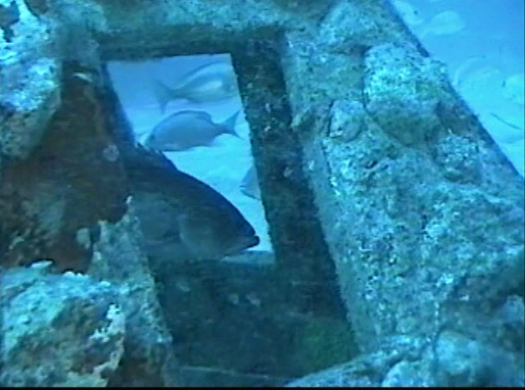
Photo by REEFMAKER @ http://reefmaker.net/
This web site is updated as I have time from other things going on. As there are a 1000 + different ways to do things, this is only my way of fishing, nothing else, and it is not the last word in fishing the area. I am by no means an expert but if you would like my opinion on something related to fishing the area, please email me at FishingDestinGuide@cox.net. It may take a few days before I get to it, so be patient. Thanks..... © Copyright 2018 Fishing Destin Guide All rights reserved |
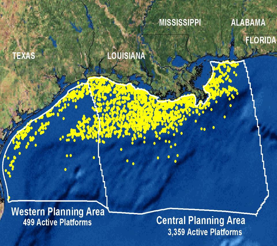
Map of the northern Gulf of Mexico showing the nearly 4,000 active oil and
gas platforms.
gas platforms.