Shankys Site 01 30:19.500 86:33.460 221° mag / 4.1 sm 2-4' 70'
General area where some steel cages filled with tires and concrete were dumped in 1989.
Shankys Site 01 A 30 18.910 86 33.256
Shankys Site 01B 30 18.800 86 33.800
-----------------------------------------------------------------------------------------------------------------------------------------------------------------------------
Pole Spot 01 30:22.130 86:35.257 270° mag / 4.3 sm 2-3' 72'
Area where concrete rubble from the old Okaloosa pier was dumped.
Pole Spot 02 30:22.147 86:35.323 271° mag / 4.4 sm
Pole Spot 03 30:22.098 86:35.319 270° mag / 4.4 sm
Pole Spot 04 30:22.064 86:35.382 269° mag / 4.5 sm
Pole Spot 05 30:22.012 86:35.391 269° mag / 4.5 sm
Pole Spot 06 30:22.029 86:35.476 269° mag / 4.6 sm
Pole Spot 07 30:22.037 86:35.455 269° mag / 4.5 sm
-----------------------------------------------------------------------------------------------------------------------------------------------------------------------------
Army Tanks
In 1994, the US Army destroyed hundreds of obsolete M60 battle tanks by dumping the in the ocean along the gulf coast. A total of
14 US Army surplus M-60 main battle tanks from the Anniston Army Depot were sunk on December 19, 1994 as part of the US Army
logistic exercise Reefex 94. Six were sunk about 1 1/2 miles south south east of the Okaloosa Island pier in 70'. One was sunk 1 1/2
mile south of the CB Buoy just north of the Eglin Barge in 68' of water. Two were sunk further east about a mile due south of the
Miss Louise in 68'. The other five tanks were sunk in deeper water, about 17 miles southeast of Destin in around 115'. All remain
intact and hold fish, with about 6' of relief in 70' of water.
Army Tank 01 30:21.761 86:35.480 265° mag / 4.6 sm
M60 Army tank, on side
Army Tank 02 30:21.787 86:35.403 265° mag / 4.5 sm
M60 Army tank, on side
ArmyTank 03 30:21.775 86:35.358 265° mag / 4.5 sm
M60 Army tank, sitting upright
Army Tank 04 30:21.794 86:35.354 265° mag / 4.5sm
M60 Army tank, sitting upright
Army Tank 05 30:22.129 86:35.074 270° mag / 4.2 sm
M60 Army tank, sitting upright
Army Tank 06 30:22.146 86:35.062 270° mag / 4.15sm
M60 Army tank
-------------------------------------------------------------------------------------------------------------------------------------------------------------------------------
AJ Bimini
Six obsolete M60 tank turrets were sunk on May 21,1998. Most are buried with little relief. General locations given.
.
AJ Biimini 01 30:19.550 86:36.060 241° mag / 6.0 sm 82' turret, sunk 5/21/1998
AJ Bimini 02 30:19.670 86:36.070 242° mag / 5.9 sm
AJ Bimini 03 30:19.660 86:36.150 242° mag / 6.0 sm
AJ Bimini 04 30:19.650 86:36.100 242° mag / 6.0 sm
AJ Bimini 04 A 30:19.530 86:36.100 241° mag / 6.05sm
AJ Bimini 04 B 30 19.625 86 36.164
AJ Bimini 05 30:19.600 86:36.200 242° mag / 6.1 sm
AJ Bimini 05 A 30 19.621 86 36.172
AJ Bimini 05 B 30 19.585 86 36.194
AJ Bimini 06 30:19.600 86:36.100 242° mag / 6.0 sm
-------------------------------------------------------------------------------------------------------------------------------------------------------------------------------
PBY 12 30:12.655 86.59.817 251° mag / 30.9 sm
Unconfirmed aircraft
-------------------------------------------------------------------------------------------------------------------------------------------------------------------------------
PBY 01 30:12.532 87:05.725 254° mag / 36.5 sm
Unconfirmed aircraft
-------------------------------------------------------------------------------------------------------------------------------------------------------------------------------
Casino Beach Rubble 30:18:727 87:07.334 266° mag / 36.5 sm 2' 60'
Concrete rubble from the old Pensacola Beach Casino Beach Casino. A lot has been covered by sand.
Casino Beach Rubble A 30:18:706 87:07.197
Casino Beach Rubble B 30:18.670 87:07.280
-----------------------------------------------------------------------------------------------------------------------------------------------------------------------------
Pensacola Wreck 01 30:17.281 87:08.857 264° mag / 38.2 sm
Unconfirmed wreck.
-----------------------------------------------------------------------------------------------------------------------------------------------------------------------------
CM Hole 04 30 11.201 87 08.514 253° mag / 39.6 sm 2-4' 89'
Cement truck mixer
-----------------------------------------------------------------------------------------------------------------------------------------------------------------------------
CM Hole 06 30 11.149 87 09.226 254° mag / 40.3 sm 6' 96'
Cement Truck mixer
Unknown 02 30:23.212 86:45.414 276° mag / 14.5 sm ??' 34'
SW Reef 66 N 30 21.101 W 86 31.921 220° mag / 1.7 sm 2' 66' n/a Yes Natural reef
-------------------------------------------------------------------------------------------------------------------------------------------------------------------------------
SW Reef 70 N 30 21.415 W 86 32.818 245° mag / 2.1 sm 2' 70' n/a Yes Unknown
-------------------------------------------------------------------------------------------------------------------------------------------------------------------------------
West Spot 45 N 30 22.172 W 86 33.666 270° mag / 2.8 sm 2' 45' n/a Yes Unknown
-------------------------------------------------------------------------------------------------------------------------------------------------------------------------------
West Spot 52 N 30 22.015 W 86 34.103 267° mag / 3.2 sm 2-4' 52' n/a Yes Unknown
-------------------------------------------------------------------------------------------------------------------------------------------------------------------------------
West Spot 49 N 30 22.052 W 86 34.179 270° mag / 2.8 sm 2' 45' n/a Yes Unknown
-------------------------------------------------------------------------------------------------------------------------------------------------------------------------------
West Spot 40 N 30 22.668 W 86 34.138 281° mag / 3.3 sm 2' 45' n/a Yes Unknown
West Spot 40 A N 30 22.658 W 86 34.182
-------------------------------------------------------------------------------------------------------------------------------------------------------------------------------
Airplane Rock N 30:20.506 W 86:31.698 204° mag / 2.2 sm 2-4'
An area of natural rock outcroppings, widely scattered
Airplane Rock A 30:20.500 86:31.696
Airplane Rock C 30:20.504 86:31.702
Airplane Rock D 30:20.503 86:31.699
Airplane Rock E 30:20.511 86:31.701
Airplane Rock F 30:20.516 86:31.701
Airplane Rock G 30:20.492 86:31.701
Airplane Rock H 30:20.524 86:31.703
Airplane Rock I 30:20.520 86:31.702
Airplane Rock J 30:20.507 86:31.715
Airplane Rock K 30:20.515 86:31.714
-------------------------------------------------------------------------------------------------------------------------------------------------------------------------------
AJ Hole N 30:20.352 W 86:32.456 217° mag / 2.7 sm
Natural reef
AJ Hole A 30:20.345 86:32.455
AJ Hole B 30:20.355 86:32.462
AJ Hole C 30:20.341 86:32.452
AJ Hole D 30:20.365 86:32.459
AJ Hole E 30:20.350 86:32.471
AJ Hole F 30:20.349 86:32.489
AJ Hole G 30:20.340 86:32.489
AJ Hole H 30:20.411 86:32.446
AJ Hole I 30:20.357 86:32.478
-------------------------------------------------------------------------------------------------------------------------------------------------------------------------------
Big Spot Reef N 30:19.254 W 86:31.020 184° mag / 3.45sm 86'
Natural Reef
Big Spot Reef A 30:19.207 86:31.008
Big Spot Reef B 30:19.183 86:30.997
-------------------------------------------------------------------------------------------------------------------------------------------------------------------------------
Four Anchor Reef N 30:18.892 W 86:31.361 189° mag / 3.9 sm 2-3' 80'
Natural reef
Four Anchor Reef A N 30:18.868 W 86:31.336
-------------------------------------------------------------------------------------------------------------------------------------------------------------------------------King
Reef A N 30:18.255 W 86:30.966 183° mag / 4.6 sm 88'
Natural reef
King Reef A 30:18.261 86:30.865
King Reef B 30:18.254 86:30.892
King Reef C 30:18.271 86:30.967
King Reef D 30:18.336 86:31.024
King Reef E 30:18.520 86:30.955
King Reef F 30:18.536 86:30.919
-------------------------------------------------------------------------------------------------------------------------------------------------------------------------------
Five Mile South Reef 01 30:18.060 86:32.341 199° mag / 5.0 sm 2-4' 90' n/a Yes
Natural reef system, depths 75-100'
Five Mile South Reef 01A 30 18.064 86 32.338
Five Mile South Reef 01B 30 18.063 86 32.348
Five Mile South Reef 01C 30 18.057 86 32.295
-------------------------------------------------------------------------------------------------------------------------------------------------------------------------------
Five Mile South Reef 02 30:18.351 86:33.288 210° mag / 5.1 sm 2-4' 90' n/a Yes
Natural reef system, depths 75-100'
-------------------------------------------------------------------------------------------------------------------------------------------------------------------------------Whitehill
Reef 01 30:19.474 86:35.086 235° mag / 5.25sm 2-6' 70-80'
Large area reef system of natural limestone rocks northeast of the Liberty Ship Thomas Hayward.
Whitehill Reef 02 30 19.922 86 34.836
Whitehill Reef 03 30 20.354 86 34.520
Whitehill Reef 04 30 18.734 86 26.211
Whitehill Reef 05 30 20.894 86 34.184
Whitehill Reef 06 30 19.909 86 36.077
Whitehill Reef 07 30 19.740 86 35.760
Whitehill Reef 08 30 20.250 86 35.442
Whitehill Reef 09 30 19.095 86 35.570
Whitehill Reef 10 30 18.662 86 35.268
Whitehill Reef 11 30 18.883 86 35.200
-------------------------------------------------------------------------------------------------------------------------------------------------------------------------------
Anchor Rock SE 30:18'807 86:36.126 235° mag / 6.5 sm 2-5' 83'
Area of natural rock ledges, 3 groups
Anchor Rock NW 30:18.904 86:36.238
Anchor Rock SW 30:18.512 86:36.247
Anchor Rock A 30:18.847 86:36.355
Anchor Rock B 30:18.859 86:36.246
-------------------------------------------------------------------------------------------------------------------------------------------------------------------------------SW
100 Foot Reef 30:18.119 86:35.502 226° mag / 6.6 sm 2-3' 100'
Natural bottom
-------------------------------------------------------------------------------------------------------------------------------------------------------------------------------
Bills Ridge 30:16.014 86:33.474 202° mag / 7.6 sm 2-4' 75' n/a Yes
Natural reef system, rocks and ledges
Bills Ridge A 30 15.730 86 33.481
-------------------------------------------------------------------------------------------------------------------------------------------------------------------------------
Bills Ridge West 30:16.140 86:34.370 208° mag / 7.8 sm 2-4' 80' n/a Yes
Natural reef system, rocks and ledges
-------------------------------------------------------------------------------------------------------------------------------------------------------------------------------
Bills Ridge North 30:16.652 86:34.170 209° mag / 7.2 sm 2-4' 92' n/a Yes
Natural reef system, rocks and ledges
-------------------------------------------------------------------------------------------------------------------------------------------------------------------------------
Big Reef 30:16.591 86:36.082 220° mag / 8.3 sm 2-4' 90' n/a Yes
Natural reef system, rocks and ledges
Big Reef A 30:16.589 86:36.086
Big Reef B 30:16.572 86:36.070
Big Reef C 30:16.564 86:36.071
Big Reef D 30:16.597 86:36.067
Big Reef E 30:16.602 86:36.062
Big Reef F 30:16.613 86:36.043
Big Reef G 30:16.631 86:36.043
Big Reef H 30:16.581 86:36.103
Big Reef I 30:16.566 86:36.140
Big Reef J 30:16.561 86:36.146
Big Reef K 30:16.552 86:36.146
Big Reef L 30:16.761 86:36.361
-------------------------------------------------------------------------------------------------------------------------------------------------------------------------------
Big Reef North 30:16.945 86:35.910 221° mag / 7.5 sm 2-4' 88' n/a Yes
Natural reef system, rocks and ledges
Big Reef North A 30:16.999 86:35.979
Big Reef North B 30:17.033 86:35.929
Big Reef North C 30 17.047 86 35.990
-------------------------------------------------------------------------------------------------------------------------------------------------------------------------------
Big Reef Northeast 30 17.249 86 35.645 221° mag / 8.3 sm 2-4' 87' n/a Yes
Natural reef system, rocks and ledges
-------------------------------------------------------------------------------------------------------------------------------------------------------------------------------
Victory Hole 30 17.000 86 41.200 242° mag / 10.3 sm ??' 93'
Natural reef area
Victory Hole A 30 16.980 86 41.130
Victory Hole B 30 17.254 86 41.226
-------------------------------------------------------------------------------------------------------------------------------------------------------------------------------
Navarre Reef 02 30:17.396 86:57.084 260° mag / 26.7 sm 2-4' 82'
Natural reef
-------------------------------------------------------------------------------------------------------------------------------------------------------------------------------
Navarre Reef 01 30:17.194 86:58.539 260° mag / 28.1 sm 2-4' 90'
Natural Reef
Navarre Reef 01 A 30 17.230 86 58.630
-------------------------------------------------------------------------------------------------------------------------------------------------------------------------------
State Line Hole 30:15.149 86:39.466 228° mag / 11.8 sm 2-4' 82'
Natural reef system, rocks and ledges
-------------------------------------------------------------------------------------------------------------------------------------------------------------------------------
Neal Flats Hole 30:12.470 87:08.502 255° mag / 39.1 sm
-------------------------------------------------------------------------------------------------------------------------------------------------------------------------------
Pensacola Reef 27 30:13.522 87:08.928 257° mag / 39.2 sm
-------------------------------------------------------------------------------------------------------------------------------------------------------------------------------Pensacola
Reef 08 30:12.648 87:08.885 255° mag / 39.4 sm
-------------------------------------------------------------------------------------------------------------------------------------------------------------------------------
Pensacola Reef 40 30:15.644 87:09.712 261° mag / 39.4 sm
Pensacola Reef 40 A 30:15.594 87:09.605
Pensacola Reef 40B 30:15.678 87:09.774
-------------------------------------------------------------------------------------------------------------------------------------------------------------------------------
Pensacola Reef 02 30:14.876 87:09.608 260° mag / 39.5 sm
Pensacola Reef 02 A 30:14.969 87:09.696
Pensacola Reef 02 B 30:14.863 87:09.693
-------------------------------------------------------------------------------------------------------------------------------------------------------------------------------
Pensacola Reef 30 30:17.613 87.10.386 264° mag / 39.7 sm 2-4' 60'
Natural Reef
-------------------------------------------------------------------------------------------------------------------------------------------------------------------------------
Pensacola Reef 45 30:14.033 87 09.561 258° mag / 39.7 sm 2-4' 100'
Natural coral reef
-------------------------------------------------------------------------------------------------------------------------------------------------------------------------------
306 Hole 30 10.871 87 08.380 253° mag / 39.6 sm 2-4' 89'
Natural reef
-------------------------------------------------------------------------------------------------------------------------------------------------------------------------------
Pensacola Reef 18 30:11.010 87 09.390 253° mag / 40.5 sm 2-4' 99'
Natural Reef
-------------------------------------------------------------------------------------------------------------------------------------------------------------------------------
Gully Hole 01 30:12.648 87 08.885 256° mag / 39.4 sm 2-4' 96'
Natural coral reef
-------------------------------------------------------------------------------------------------------------------------------------------------------------------------------
Gully Hole 02 30:12.255 87 08.885 256° mag / 39.5 sm 2-4' 93'
Natural coral reef
-------------------------------------------------------------------------------------------------------------------------------------------------------------------------------
Greens Hole G 30:11.437 87:05.362 252° mag / 36.5 sm
Natural reef area that runs into federal waters also.
Greens Hole H 30:11.585 87:05.565
Greens Hole E 30:12.001 87:04.8221
-------------------------------------------------------------------------------------------------------------------------------------------------------------------------------
Pensacola Reef 43 30:16.822 87:07,734 262° mag / 37.2 sm
Pensacola Reef 43 A 30:16.910 87:07.810
-------------------------------------------------------------------------------------------------------------------------------------------------------------------------------
Pensacola Reef 01 30:11.968 87:06.786 254° mag / 37.7 sm
-------------------------------------------------------------------------------------------------------------------------------------------------------------------------------
136 Hole 30:14.554 87:08.546 259° mag / 38.5 sm
136 Hole A 30:14.716 87:08.395
-------------------------------------------------------------------------------------------------------------------------------------------------------------------------------
Pensacola Reef 37 30:12.477 87:08.100 255° mag / 38.7 sm
Pensacola Reef 37 A 30:12.566 87:08.118
-------------------------------------------------------------------------------------------------------------------------------------------------------------------------------
Jamies Hole 30:14.982 87:08.820 260° mag / 38.8 sm
Jamies Hole A 30:15.080 87:08.941
-------------------------------------------------------------------------------------------------------------------------------------------------------------------------------
Pensacola Reef 22 30:15.867 87:09.096 261° mag / 38.8 sm
Rock pile
-------------------------------------------------------------------------------------------------------------------------------------------------------------------------------
Pensacola Reef 17 30:18.279 87:09.701 265° mag / 38.9 sm
-------------------------------------------------------------------------------------------------------------------------------------------------------------------------------
96 Hole 30:15.492 87:09.277 261° mag / 39.0 sm
-------------------------------------------------------------------------------------------------------------------------------------------------------------------------------Pensacola
Reef 55 30:12.515 87:08.405 255° mag / 39.0 sm Coral heads
-------------------------------------------------------------------------------------------------------------------------------------------------------------------------------
Pensacola Reef 41 30:11.300 87:04.800 252° mag / 36.1 sm
-------------------------------------------------------------------------------------------------------------------------------------------------------------------------------
SW Reef 70 N 30 21.415 W 86 32.818 245° mag / 2.1 sm 2' 70' n/a Yes Unknown
-------------------------------------------------------------------------------------------------------------------------------------------------------------------------------
West Spot 45 N 30 22.172 W 86 33.666 270° mag / 2.8 sm 2' 45' n/a Yes Unknown
-------------------------------------------------------------------------------------------------------------------------------------------------------------------------------
West Spot 52 N 30 22.015 W 86 34.103 267° mag / 3.2 sm 2-4' 52' n/a Yes Unknown
-------------------------------------------------------------------------------------------------------------------------------------------------------------------------------
West Spot 49 N 30 22.052 W 86 34.179 270° mag / 2.8 sm 2' 45' n/a Yes Unknown
-------------------------------------------------------------------------------------------------------------------------------------------------------------------------------
West Spot 40 N 30 22.668 W 86 34.138 281° mag / 3.3 sm 2' 45' n/a Yes Unknown
West Spot 40 A N 30 22.658 W 86 34.182
-------------------------------------------------------------------------------------------------------------------------------------------------------------------------------
Airplane Rock N 30:20.506 W 86:31.698 204° mag / 2.2 sm 2-4'
An area of natural rock outcroppings, widely scattered
Airplane Rock A 30:20.500 86:31.696
Airplane Rock C 30:20.504 86:31.702
Airplane Rock D 30:20.503 86:31.699
Airplane Rock E 30:20.511 86:31.701
Airplane Rock F 30:20.516 86:31.701
Airplane Rock G 30:20.492 86:31.701
Airplane Rock H 30:20.524 86:31.703
Airplane Rock I 30:20.520 86:31.702
Airplane Rock J 30:20.507 86:31.715
Airplane Rock K 30:20.515 86:31.714
-------------------------------------------------------------------------------------------------------------------------------------------------------------------------------
AJ Hole N 30:20.352 W 86:32.456 217° mag / 2.7 sm
Natural reef
AJ Hole A 30:20.345 86:32.455
AJ Hole B 30:20.355 86:32.462
AJ Hole C 30:20.341 86:32.452
AJ Hole D 30:20.365 86:32.459
AJ Hole E 30:20.350 86:32.471
AJ Hole F 30:20.349 86:32.489
AJ Hole G 30:20.340 86:32.489
AJ Hole H 30:20.411 86:32.446
AJ Hole I 30:20.357 86:32.478
-------------------------------------------------------------------------------------------------------------------------------------------------------------------------------
Big Spot Reef N 30:19.254 W 86:31.020 184° mag / 3.45sm 86'
Natural Reef
Big Spot Reef A 30:19.207 86:31.008
Big Spot Reef B 30:19.183 86:30.997
-------------------------------------------------------------------------------------------------------------------------------------------------------------------------------
Four Anchor Reef N 30:18.892 W 86:31.361 189° mag / 3.9 sm 2-3' 80'
Natural reef
Four Anchor Reef A N 30:18.868 W 86:31.336
-------------------------------------------------------------------------------------------------------------------------------------------------------------------------------King
Reef A N 30:18.255 W 86:30.966 183° mag / 4.6 sm 88'
Natural reef
King Reef A 30:18.261 86:30.865
King Reef B 30:18.254 86:30.892
King Reef C 30:18.271 86:30.967
King Reef D 30:18.336 86:31.024
King Reef E 30:18.520 86:30.955
King Reef F 30:18.536 86:30.919
-------------------------------------------------------------------------------------------------------------------------------------------------------------------------------
Five Mile South Reef 01 30:18.060 86:32.341 199° mag / 5.0 sm 2-4' 90' n/a Yes
Natural reef system, depths 75-100'
Five Mile South Reef 01A 30 18.064 86 32.338
Five Mile South Reef 01B 30 18.063 86 32.348
Five Mile South Reef 01C 30 18.057 86 32.295
-------------------------------------------------------------------------------------------------------------------------------------------------------------------------------
Five Mile South Reef 02 30:18.351 86:33.288 210° mag / 5.1 sm 2-4' 90' n/a Yes
Natural reef system, depths 75-100'
-------------------------------------------------------------------------------------------------------------------------------------------------------------------------------Whitehill
Reef 01 30:19.474 86:35.086 235° mag / 5.25sm 2-6' 70-80'
Large area reef system of natural limestone rocks northeast of the Liberty Ship Thomas Hayward.
Whitehill Reef 02 30 19.922 86 34.836
Whitehill Reef 03 30 20.354 86 34.520
Whitehill Reef 04 30 18.734 86 26.211
Whitehill Reef 05 30 20.894 86 34.184
Whitehill Reef 06 30 19.909 86 36.077
Whitehill Reef 07 30 19.740 86 35.760
Whitehill Reef 08 30 20.250 86 35.442
Whitehill Reef 09 30 19.095 86 35.570
Whitehill Reef 10 30 18.662 86 35.268
Whitehill Reef 11 30 18.883 86 35.200
-------------------------------------------------------------------------------------------------------------------------------------------------------------------------------
Anchor Rock SE 30:18'807 86:36.126 235° mag / 6.5 sm 2-5' 83'
Area of natural rock ledges, 3 groups
Anchor Rock NW 30:18.904 86:36.238
Anchor Rock SW 30:18.512 86:36.247
Anchor Rock A 30:18.847 86:36.355
Anchor Rock B 30:18.859 86:36.246
-------------------------------------------------------------------------------------------------------------------------------------------------------------------------------SW
100 Foot Reef 30:18.119 86:35.502 226° mag / 6.6 sm 2-3' 100'
Natural bottom
-------------------------------------------------------------------------------------------------------------------------------------------------------------------------------
Bills Ridge 30:16.014 86:33.474 202° mag / 7.6 sm 2-4' 75' n/a Yes
Natural reef system, rocks and ledges
Bills Ridge A 30 15.730 86 33.481
-------------------------------------------------------------------------------------------------------------------------------------------------------------------------------
Bills Ridge West 30:16.140 86:34.370 208° mag / 7.8 sm 2-4' 80' n/a Yes
Natural reef system, rocks and ledges
-------------------------------------------------------------------------------------------------------------------------------------------------------------------------------
Bills Ridge North 30:16.652 86:34.170 209° mag / 7.2 sm 2-4' 92' n/a Yes
Natural reef system, rocks and ledges
-------------------------------------------------------------------------------------------------------------------------------------------------------------------------------
Big Reef 30:16.591 86:36.082 220° mag / 8.3 sm 2-4' 90' n/a Yes
Natural reef system, rocks and ledges
Big Reef A 30:16.589 86:36.086
Big Reef B 30:16.572 86:36.070
Big Reef C 30:16.564 86:36.071
Big Reef D 30:16.597 86:36.067
Big Reef E 30:16.602 86:36.062
Big Reef F 30:16.613 86:36.043
Big Reef G 30:16.631 86:36.043
Big Reef H 30:16.581 86:36.103
Big Reef I 30:16.566 86:36.140
Big Reef J 30:16.561 86:36.146
Big Reef K 30:16.552 86:36.146
Big Reef L 30:16.761 86:36.361
-------------------------------------------------------------------------------------------------------------------------------------------------------------------------------
Big Reef North 30:16.945 86:35.910 221° mag / 7.5 sm 2-4' 88' n/a Yes
Natural reef system, rocks and ledges
Big Reef North A 30:16.999 86:35.979
Big Reef North B 30:17.033 86:35.929
Big Reef North C 30 17.047 86 35.990
-------------------------------------------------------------------------------------------------------------------------------------------------------------------------------
Big Reef Northeast 30 17.249 86 35.645 221° mag / 8.3 sm 2-4' 87' n/a Yes
Natural reef system, rocks and ledges
-------------------------------------------------------------------------------------------------------------------------------------------------------------------------------
Victory Hole 30 17.000 86 41.200 242° mag / 10.3 sm ??' 93'
Natural reef area
Victory Hole A 30 16.980 86 41.130
Victory Hole B 30 17.254 86 41.226
-------------------------------------------------------------------------------------------------------------------------------------------------------------------------------
Navarre Reef 02 30:17.396 86:57.084 260° mag / 26.7 sm 2-4' 82'
Natural reef
-------------------------------------------------------------------------------------------------------------------------------------------------------------------------------
Navarre Reef 01 30:17.194 86:58.539 260° mag / 28.1 sm 2-4' 90'
Natural Reef
Navarre Reef 01 A 30 17.230 86 58.630
-------------------------------------------------------------------------------------------------------------------------------------------------------------------------------
State Line Hole 30:15.149 86:39.466 228° mag / 11.8 sm 2-4' 82'
Natural reef system, rocks and ledges
-------------------------------------------------------------------------------------------------------------------------------------------------------------------------------
Neal Flats Hole 30:12.470 87:08.502 255° mag / 39.1 sm
-------------------------------------------------------------------------------------------------------------------------------------------------------------------------------
Pensacola Reef 27 30:13.522 87:08.928 257° mag / 39.2 sm
-------------------------------------------------------------------------------------------------------------------------------------------------------------------------------Pensacola
Reef 08 30:12.648 87:08.885 255° mag / 39.4 sm
-------------------------------------------------------------------------------------------------------------------------------------------------------------------------------
Pensacola Reef 40 30:15.644 87:09.712 261° mag / 39.4 sm
Pensacola Reef 40 A 30:15.594 87:09.605
Pensacola Reef 40B 30:15.678 87:09.774
-------------------------------------------------------------------------------------------------------------------------------------------------------------------------------
Pensacola Reef 02 30:14.876 87:09.608 260° mag / 39.5 sm
Pensacola Reef 02 A 30:14.969 87:09.696
Pensacola Reef 02 B 30:14.863 87:09.693
-------------------------------------------------------------------------------------------------------------------------------------------------------------------------------
Pensacola Reef 30 30:17.613 87.10.386 264° mag / 39.7 sm 2-4' 60'
Natural Reef
-------------------------------------------------------------------------------------------------------------------------------------------------------------------------------
Pensacola Reef 45 30:14.033 87 09.561 258° mag / 39.7 sm 2-4' 100'
Natural coral reef
-------------------------------------------------------------------------------------------------------------------------------------------------------------------------------
306 Hole 30 10.871 87 08.380 253° mag / 39.6 sm 2-4' 89'
Natural reef
-------------------------------------------------------------------------------------------------------------------------------------------------------------------------------
Pensacola Reef 18 30:11.010 87 09.390 253° mag / 40.5 sm 2-4' 99'
Natural Reef
-------------------------------------------------------------------------------------------------------------------------------------------------------------------------------
Gully Hole 01 30:12.648 87 08.885 256° mag / 39.4 sm 2-4' 96'
Natural coral reef
-------------------------------------------------------------------------------------------------------------------------------------------------------------------------------
Gully Hole 02 30:12.255 87 08.885 256° mag / 39.5 sm 2-4' 93'
Natural coral reef
-------------------------------------------------------------------------------------------------------------------------------------------------------------------------------
Greens Hole G 30:11.437 87:05.362 252° mag / 36.5 sm
Natural reef area that runs into federal waters also.
Greens Hole H 30:11.585 87:05.565
Greens Hole E 30:12.001 87:04.8221
-------------------------------------------------------------------------------------------------------------------------------------------------------------------------------
Pensacola Reef 43 30:16.822 87:07,734 262° mag / 37.2 sm
Pensacola Reef 43 A 30:16.910 87:07.810
-------------------------------------------------------------------------------------------------------------------------------------------------------------------------------
Pensacola Reef 01 30:11.968 87:06.786 254° mag / 37.7 sm
-------------------------------------------------------------------------------------------------------------------------------------------------------------------------------
136 Hole 30:14.554 87:08.546 259° mag / 38.5 sm
136 Hole A 30:14.716 87:08.395
-------------------------------------------------------------------------------------------------------------------------------------------------------------------------------
Pensacola Reef 37 30:12.477 87:08.100 255° mag / 38.7 sm
Pensacola Reef 37 A 30:12.566 87:08.118
-------------------------------------------------------------------------------------------------------------------------------------------------------------------------------
Jamies Hole 30:14.982 87:08.820 260° mag / 38.8 sm
Jamies Hole A 30:15.080 87:08.941
-------------------------------------------------------------------------------------------------------------------------------------------------------------------------------
Pensacola Reef 22 30:15.867 87:09.096 261° mag / 38.8 sm
Rock pile
-------------------------------------------------------------------------------------------------------------------------------------------------------------------------------
Pensacola Reef 17 30:18.279 87:09.701 265° mag / 38.9 sm
-------------------------------------------------------------------------------------------------------------------------------------------------------------------------------
96 Hole 30:15.492 87:09.277 261° mag / 39.0 sm
-------------------------------------------------------------------------------------------------------------------------------------------------------------------------------Pensacola
Reef 55 30:12.515 87:08.405 255° mag / 39.0 sm Coral heads
-------------------------------------------------------------------------------------------------------------------------------------------------------------------------------
Pensacola Reef 41 30:11.300 87:04.800 252° mag / 36.1 sm
Brown Barge N 30:21.537 W 86:35.614 262° mag / 4.8 sm
Barge, 200' long, sunk in 1977 in 74' of water. Also known as the Ft Walton Barge, Butler Barge. Very easy to get hung up here if
you are drifting your line.
Brown Barge A 30:21.533 86:35.610
Brown Barge B 30:21.534 86:35.611
Brown Barge C 30:21.542 86:35.618
Brown Barge D 30:21.529 86:35.620
Brown Barge E 30:21.522 86:35.622
-----------------------------------------------------------------------------------------------------------------------------------------------------------------------------
Barrel Barge N 30:21.813 W 86:36.084 267° mag / 5.2 sm
Barge loaded with 22 old round gas storage tanks sunk in July 1992. 6 -12' relief, wide area of good fishing, usually a lot of Ruby
Red lips, small red snapper. The divers say there is a resident Goliath Grouper there. In 70' of water.
Barrel Barge A 30:21.823 86:36.094
Barrel Barge B 30:21.819 86:36.086
Barrel Barge C 30:21.803 86:36.086
Barge Barge D 30:21.809 86:36.083
Barrel Barge E 30:21.810 86:36.094
Barrel Barge F 30:21.807 86:36.087
-------------------------------------------------------------------------------------------------------------------------------------------------------------------------------
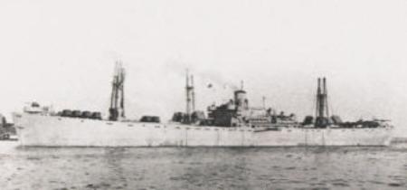
Liberty Ship Thomas Hayward 232° mag / 6.9 sm
One of the Liberty ships sunk on April 17, 1977 in 83' of water. Large area to fish, will see 5-10 boats anchored there sometimes in
the summer. 360' steel WWII liberty ship, widely scattered.
FWB Liberty Ship A N 30:18.387 W 86:36.207
FWB Liberty Ship B 30:18.388 86:36.203
FWB Liberty Ship C 30:18.399 86:36.209
FWB Liberty Ship D 30:18.384 86:36.212
FWB Liberty Ship E 30:18.401 86:36.206
FWB Liberty Ship F 30:18.398 86:36.222
FWB Liberty Ship G 30:18.385 86:36.210
FWB Liberty Ship H 30:18.405 86:36.199
FWB Liberty Ship I 30:18.403 86:36.216
FWB Liberty Ship J 30:18.404 86:36.223
FWB Liberty Ship K 30:18.414 86:36.221
FWB Liberty Ship L 30:18.390 86:36.233
FWB Liberty Ship M 30:18.376 86:36.222
-------------------------------------------------------------------------------------------------------------------------------------------------------------------------------
West Barge N 30:21.600 W 86:41.400 268° mag / 10.5 sm
Not confirmed, unknown.
-------------------------------------------------------------------------------------------------------------------------------------------------------------------------------
Shrimp Boat Flossie N 30:20.551 W 86:42.663 263° mag / 11.9 sm
Reported 77' shrimp boat, used as target for aerial gunnery, sunk in 80' of water. Not confirmed.
-------------------------------------------------------------------------------------------------------------------------------------------------------------------------------
Mr Happy Tug N 30:16.684 W 86:42.829 244° mag / 13.5 sm
Unconfirmed, in 76'.
-------------------------------------------------------------------------------------------------------------------------------------------------------------------------------
Butthead Tug N 30:16.083 W 86:43.486 243° mag / 14.4sm
Unconfirmed tugboat in 78'.
Butthead Tug A M 30:16.063 W 86:43.451
-------------------------------------------------------------------------------------------------------------------------------------------------------------------------------
LSU Buoy N 30:23.057 W 86:45.797 281° mag / 14.83 sm
Not a wreck, but a data buoy (WAVCIS Buoy) about a half mile off the Eglin beach. About 1.2 sm west of the Eglin "Space Tower.
Always a good place to check for Cobia in the spring.
-------------------------------------------------------------------------------------------------------------------------------------------------------------------------------
Eglin Beach Wreck N 30:23.308 W 86:46.695 276° mag / 15.7 sm
An unknown wreck just outside the surf on the Eglin beach between Ft Walton and Navarre. About 1.8 sm west of the Eglin "Space
Tower".
Can be seen on google and other mapping services aerial photos:
-------------------------------------------------------------------------------------------------------------------------------------------------------------------------------NAVARRE
BARGE N 30:17.702 W 86:49.036 256° mag / 18.8 sm
Unknown barge sunk in 84' of water, about 10' of relief. Good for flounder, trigger, snapper. aka Cobia Barge
Navarre Barge A 30 17.699 86 49.032
Navarre Barge B 30 17.697 86 49.027
Navarre Barge C 30 17.700 86 49.020
Navarre Barge D 30 17.703 86 49.030
Navarre Barge E 30 17.699 86 49.034
Navarre Barge F 30 17.705 86 49.043
-------------------------------------------------------------------------------------------------------------------------------------------------------------------------------
Navarre Navy Barge N 30:15.885 W 86;49.365 250° mag / 19.8 sm
Unconfirmed numbers
-------------------------------------------------------------------------------------------------------------------------------------------------------------------------------
Elmore Barge N 30:15.467 W 86:49.950 250° mag / 20.5 sm
Unconfirmed numbers
-------------------------------------------------------------------------------------------------------------------------------------------------------------------------------
Barnes Site 06 M 30:15.000 W 86:50.0000 248° mag / 20.8 sm
General area where unknown materials were dumped in the 1970s to make an artificial reef. Probably most of it scattered or buried
by the hurricanes.
-------------------------------------------------------------------------------------------------------------------------------------------------------------------------------
Lost Tug Mad Dog N 30:12.072 W 86 57.974 249° mag / 29.4 sm
Reportedly a 105' tugboat that was sunk in a hurricane in 78' of water. aka Whiteman Tug
Lost Tug Mad Dog A 30 12.012 86 57.915
Lost Tug Mad Dog B 30 12.064 86 57.981
Lost Tug Mad Dog C 30 12.073 86 57.978
Lost Tug Mad Dog D 30 12.090 86 57.990
Lost Tug Mad Dog E 30 12.079 86 58.046
Lost Tug Mad Dog F 30 11.921 86 58.028
-------------------------------------------------------------------------------------------------------------------------------------------------------------------------------
Brass Wreck N 30:12.847 W 87:03.137 253° mag / 33.8 sm
Reportedly a 250' wooden hull ship sunk in the 1800s in 92' of water.
Brass Wreck B 30:13.131 87:02.980
Brass Wreck C 30:12.810 87:03.190
Brass Wreck D 30:12.853 87:03.216
-------------------------------------------------------------------------------------------------------------------------------------------------------------------------------
Min Barge N 30:13.220 W 87:03,190 254° mag / 33.8 sm
Unconfirmed numbers
-------------------------------------------------------------------------------------------------------------------------------------------------------------------------------
Browns New Tug N 30:19.468 W 87:06.435 267° mag / 35.5 sm
Unconfirmed numbers
-------------------------------------------------------------------------------------------------------------------------------------------------------------------------------
Tex Edwards Barge N 30:16.138 W 87:10.157 262° mag / 39.5 sm
Tex Edwards Barge A 30:16.140 87:10.160
Tex Edwards Barge B 30:16.126 87:09.898
-------------------------------------------------------------------------------------------------------------------------------------------------------------------------------
Liberty Joseph Meek N 30:16.348 W 87:09.550 262° mag / 39.1 sm
480' WWII liberty ship sunk November 1976 in 90'. About 20' relieft.
Liberty Joseph Meek A 30:16.272 87:09.555
Liberty Joseph Meek B 30:16.420 87:09.511
Liberty Joseph Meek C 30:16.361 87:09.560
Liberty Joseph Meek D 30:16.293 87:09.520
Liberty Joseph Meek E 30:16.384 87:09.574
Liberty Joseph Meek F 30:16.390 87:09.566
-------------------------------------------------------------------------------------------------------------------------------------------------------------------------------
82nd Barge N 30:16.253 W87:09.136 262° mag / 38.7 sm
Unknown barge
82nd Barge A 30:16.180 87:09.201
82nd Barge B 30:16.383 87:08.724
82nd Barge C 30:16.351 87:08.979
View Destin GPS - State Waters: WEST 10-35sm in a larger map

View Destin GPS - State Wates:West of Destin Pass in a larger map

Ships, Tugboats, Barges etc 0 -35 sm WEST of the Destin CB Buoy All distances and bearings are from the Destin CB Buoy in statue miles |
NATURAL BOTTOM, LEDGES, ROCKS, ETC |
ARTIFICIAL REEFS |
| Destin GPS Numbers State Waters - West 0 - 40 sm of the Destin CB Buoy |

Photo by
James Williams
James Williams
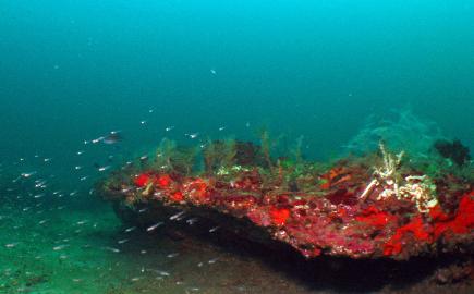
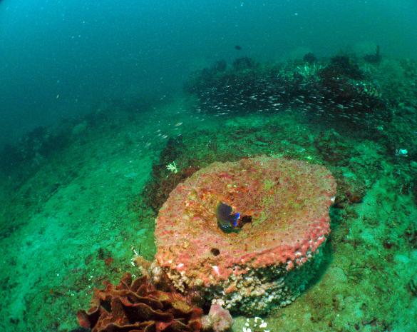
Photo by James Williams
Photo by James Williams


| Destin State waters (within 9 NM of coast) 10 - 40 sm of CB Buoy |
| Destin State waters (within 9 NM of coast) 0 - 10 sm of CB Buoy |
| Coordinates are displayed in degrees and decimal minutes. If you need to convert to another display, click on this link: Boulter LAT/LONG Converter . |
| For a printer friendly copy of these coordinates click here: Destin State Waters -WEST GPS Numbers |
Links to other sites with information on the Thomas
Hayward
Liberty Ship Thomas Hayard Dive
m
Hayward
Liberty Ship Thomas Hayard Dive
m
Links to other sites with information on the Brown Barge.
Brown Barge Dive
l
Brown Barge Dive
l
Links to other sites with information on the Barrel Barge.
Links to other sites with information on the Navarre Barge.
Links to other sites with information on the LSU Buoy:
LSU WAVCIS network
LSU WAVCIS network
Links to other sites with information on the Lost Tuge Mad Dog.
Links to other sites with information on the Tex Edwards Barge
Links to other sites with information on the Liberty ship Joseph Meek
Links to other sites with information on the 82nd Barge
Photo by James Williams


Photo by James Williams
Photo by James Williams


