
View CHOCTAWHATCHEE RIVER in a larger map

Steele Field Landing Boat Ramp N 30 22.576' W 86 1.383' 492 Moss Ave Fee: $ 2.00 Honor Box Single lane concrete ramp. On private property but public use allowed with fee. Last visited: Feb 2011 |
Pine Log Landing Boat Ramp N 30 24.465' W 85 54.602' Fee: None Single lane concrete boat ramp at the south end of Pine Log Landing Road. Good ramp, parking for 10+ vehicles, turn-around area, one trash can. Last visited: Feb 2011 |
Jenkins Landing Boat Ramp 5396 Choctaw Road Vernon, FL 32462 GPS: N 30 34.849 W 85 53.299 Washington County operated park and boat ramp. Fee: None Single concrete boat ramp. Parking for 20+ vehicles in open field. Camping allowed. Pavilion with picnic tables, grill, trash can, porta-potti. Last visited: August 2010 |
Billy Lee Landing Boat Ramp (aka Hinson Crossroads boat ramp, Douglas Ferry Landing) 6049 Douglas Ferry Rd Caryville, Fl 32427 GPS: N 30 40.161 W 85 52.203 Washington county operated park and boat ramp. Two wide single lane concrete boat ramps. Northern ramp has a lot of shoaling and is usable only by small boats. Southern one is fine. Parking for 30+ vehicles, no designated parking lanes. Park has a pavilion, picnic tables, porta-potti, trash cans, grill, fire pit. Last visited: Aug 20 |
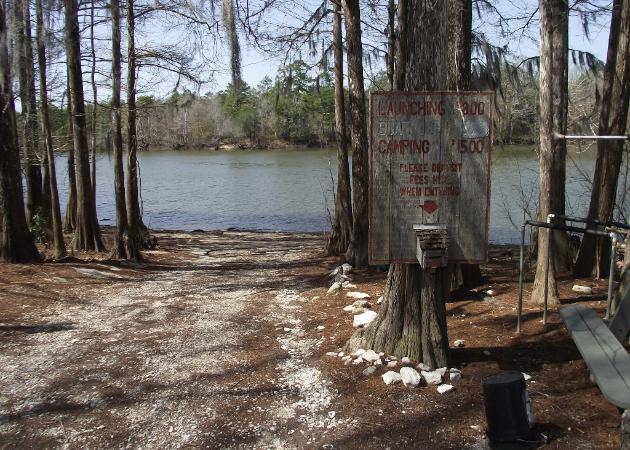
Cedar Tree Landing Boat Ramp 4985 Cedar Tree Landing Rd Ebro, Fl 32437 GPS: N 30 28.220 W 85 52.539 Fee: $ 2.00 donation, honor box at ramp. However, box is unlocked and does not look secure. Washington County operated boat ramp and park. (850) 638-6078 Single lane concrete ramp, steep. Suitable for jon boats, bass boats. Parking for 15-20 vehicles. Covered pavilion with picnic tables, trash container, porta-potti. Last visit: Dec 2014 |
Boynton Cutoff Landing Boat Ramp South end of Boynton Cutoff Rd. Vernon, FL GPS: N 30 31.427 W 85 52.272 NWF Water Management District Ramp Excellent, wide single-lane ramp. Parking for 7-10 vehicles. 1 picnic table, trash can, fire pit, grill, porta-potti. No potable water or electric. Camping permitted. Last visited: Aug 2010 |
| Otter Creek Boat Ramp N 30 23.192 W 85 58.015 Fee: None Dirt ramp. Should be able to launch small boats here. Small dirt parking area for 2-3 vehicles with trailers. Narrow road to it. Last visited: Feb 2011 |
Mann's Landing Boat Ramp N 30 26.991' W 85 53.496' Closed |
River Run R/V Park Boat Ramp 5178 Boynton Cutoff Road Vernon, FL 32462-3889 850-535-5359 GPS: N 30 31.587 W 85 52.372 Fee: Yes Single ramp Last visited: |
Gum Creek Landing Boat Ramp 2 |
| Caryville Landing Boat Ramp 4664 Boatramp Rd Caryville, Fl 32427 GPS: N 30 46.501 W 85 49.633 Fee: None Washington county operated park and boat ramp Single lane concrete boat ramp. Nice park next to the Hwy 90 bridge. Lots of parking, 30+ vehicles. There is a small picnic area a hundred yards east of the ramp with picnic tables, pavilion, trash cans. last visited: August 2010 |
Boat Ramp Road Launch South End of Boat Ramp Rd (dirt) Caryville, FL 32427 GPS: N 30 47.702 W 85 49.405 Fee: None Walking access to the Choctawhatchee River and Wrights Creek. (No ramp, carry in). Parking for about 10 vehicles. No facilities. Isolated. Last visited: August 2010 |
Ward Landing Boat Ramp West end of Boat Ramp Rd Caryville, FL 32427 GPS: N 30 48.697 W 85 49.671 Fee: None FWC operated boat ramp Single concrete boat ramp. Unimproved (dirt) parking area for about 5-8 vehicles along the road/open area at the top of the ramp. Trash cans, no other facilities. Boat Ramp sign on Hwy 179, turn left on Boat Ramp Rd, go 0.8 miles, turn right on Boat Ramp Rd to the end. Dirt road. last visited: August 2010 |
Bear Hewett Landing end of dirt road Caryville, FL 32427 GPS: 30 48.868 W 85 50.333 NW Florida Water Management District ramp Unimproved dirt ramp with parking for 10+ vehicles |
Curry Ferry Boat Ramp 1465 Curry Ferry Rd Pittman, FL GPS: N 30 55.140 W 85 51.107 Fee: None FWC/NWFWMD operated ramp. Long, steep single lane concrete boat ramp. Nice grassy area at top of small bluff overlooking a slough of the river. Parking for 30+ vehicles, also co located with the area's baseball field. No facilities at the boat ramp itself. last visited: August 2010 |
Pittman Boat Ramp South end of Choctawhatchee Lane 2248 Hwy 2 Pittman, FL GPS: N 30 56.862 W 85 50.603 Fee: None FWC/NWFWMD park and ramp Long, steep single lane concrete boat ramp. Located in a nice park on a small bluff overlooking the Choctawhatchee River, just south of the Hwy 2 bridge. Park had a pavilion, 2 picnic tables, grill, trash cans. Parking for 20+ vechicles in large grassy field. River was very low during August visit, large sand bar at bottom of ramp making boat launch impossible, would have to have carried it 50 '. last visited: Aug 2010 |


Pine Log Park Boat Ramp N 30 24.602' W 85 53.178' Nice single lane concrete ramp. Unimproved (grass/dirt) parking area for 15+ vehicles with trailers. Two picnic tables, trash can. No bathrooms or lights. Ramp is 1.4 miles from the paved road (Pine Logging Road/Gumlock Cemetary Rd). At the 0.5 mile point, they have stopped putting gravel down and it is sand/dirt the rest of the way. Some areas have deep soft sand, need to keep your speed up throught them. At the 1.2 mile point, you need to bear right, the road straight ahead is soft sand. Bay County boat ramp Last visited: Feb 2011 |
The Landing Boat Ramp N 30 26.174' W 85 54.090' Fee: $ 3.00 launch $15.00 camp overnight Private ramp with public use allowed for fee. Nice wide concrete ramp with parking for 6+ vehicles with trailers. Honor box next to ramp. Owner lives next to ramp. Last visited: Feb 2011 |


Fishing Destin Guide©
Rivers & Creeks - Choctawhatchee River
Boat Ramps - East Bank
A local's guide to fishing around Destin and the Florida Panhandle
Rivers & Creeks - Choctawhatchee River
Boat Ramps - East Bank
A local's guide to fishing around Destin and the Florida Panhandle
Known as the "luckiest fishing village", Destin is the home to some of the best saltwater fishing in the United States. The 100 Fathom (600' depth) Curve of the Gulf of Mexico draws closer to Destin than any other spot in Florida. This, along with Destin's close proximity to the East Pass and the Gulf of Mexico, allows quick access to the Gulf of Mexico's fishing bounty. The purpose of this site is to acquaint a new fisherman to the Destin area - our local facilities, fish, waters and fishing methods. Tight lines and good fishing! |
Fishing the Rivers & Creeks around Destin Choctawhatchee River Boat Ramps East Bank South to North |
Choctawhatchee River East Bank Boat Ramps |
Choctawhatchee River |
This web site is updated as I have time from other things going on. As there are a 1000 + different ways to do things, this is only my way of fishing, nothing else, and it is not the last word in fishing the area. I am by no means an expert but if you would like my opinion on something related to fishing the area, please email me at FishingDestinGuide@cox.net. It may take a few days before I get to it, so be patient. Thanks..... © Copyright 2014 Fishing Destin Guide All rights reserved |
